


Planning Tools

Beach Conditions Reporting System(BCRS)
Check beach conditions before you head to the water on Mote Marine Laboratory & Aquarium’s Beach Conditions Reporting System (BCRS) at visitbeaches.org or on the BCRS – Mote Marine Laboratory mobile app, with reporting locations in Florida, South Carolina, and Alabama relaying information from trained volunteers about weather and surf conditions, tides, crowds, debris, drift algae, jellyfish, and more. You can also find information about beach and park amenities, as well as a list of valuable resources and educational materials for various topics.
Marine Weather Portal
Curious about the wave heights or wind speed before deciding whether to leave the dock? Access free coastal and offshore observations and forecasts in one convenient location. The Marine Weather Portal is a map-based interface that provides access to local National Weather Service forecasts, real-time buoy and coastal station data, hazard alerts, and radar data.
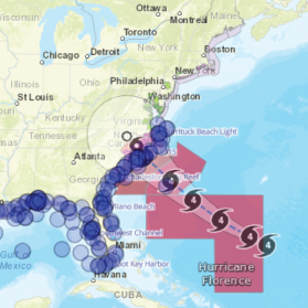
Eyes on the Storm
Eyes on the Storm is an interactive portal that connects you to live and past hurricane and tropical storm data. The tool pulls data from within 50 miles of a hurricane’s path and showcases the highest wind speeds and wave heights and lowest barometric pressure.